Switching to OpenStreetMap from Google Maps
I have been going on with my "degooglifying" efforts for a while now, however, Google Maps is something hard to get rid of. It offers so many features, especially when visiting a new country/city. Now I finally found a solution.
Here you go, my first blog post.
The features I want to have in the replacement
Just a handful of them:
- Offline maps
- Walking / Cycling navigation
- Public transportation
- Address / POI search
- Optionally satellite imagery
And all of these both on mobile and my desktop. Of course, you cannot find a solution that truly replaces Google Maps; however, I found a solution which although consists of multiple services, apps, and software and is better than Google Maps!
I tried Maps.ME, however, it's very simplistic and doesn't have all the features I wanted. What especially hurts is the POI search; very difficult to use and get actual results.
Meet OsmAnd
First, check out OsmAnd's website. As you can see, it has plenty of features, probably more than you need. And it's OpenSource; Get it on F-Droid, Google Play or App Store
OsmAnd ❤️ Wikipedia
Besides it has all the features I wanted, the best of all I loved is that it can place Wikipedia "articles" on the map. For a geek traveler, who wants to know a lot of facts about a given place, building, square, region, whatever, I don't know how I could live without this before...
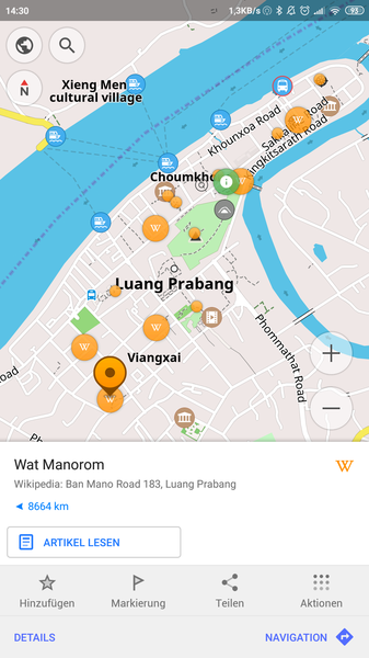
On the screenshot, the orange circles with a white W in them represent Wikipedia articles that
were geo-tagged; Clicking on them, a popup opens and you can read the (offline, cached) Wikipedia
article; in this case, about the Manorom Buddhist Temple.
OsmAnd ❤️ Wikivoyage
Okay, now this is the big deal here. For a year now, I am not buying yet another travel book when I go somewhere; This time I bought Lonely Planet on Kindle, but that's it. I try to use the excellent Wikivoyage and also contribute back to it.
One of Wikivoyage's best features is that the listed "POI"s are put on a map (see example). What I did in the past, I printed this map and tried to use Google Maps / Maps.ME together with the clumsy piece of A4 paper...
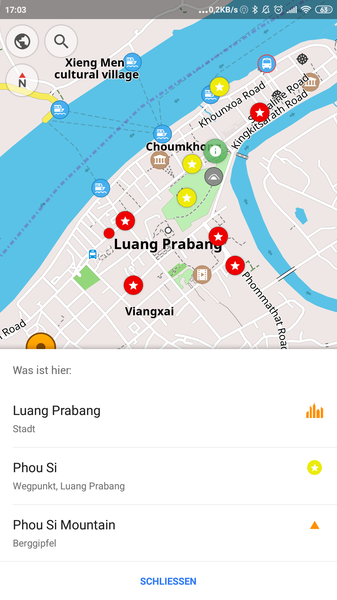
Well, guess what: OsmAnd can display the POIs from any given Wikivoyage article on an overlay; This is the best feature so far, and a must-have for travelers. User experience-wise this is more powerful and convenient than anything Lonely Planet can give you. The Wikivoyage articles are also downloaded offline, so you can read it while roaming around without network connectivity.
Try it and... contribute!
I recommend trying out OsmAnd, it's life-changing. The UI is a bit... strange compared to any other Android applications, and you can easily get lost in the settings / galore of features. However, at the same time, it's refreshing. Finally, a software that reminds me of the complex and feature-rich applications from 15-20 years ago; something that is replaced long ago by dumb smartphone apps.
The rendering of the map does not look fancy; sometimes I would say it's annoyingly flickering. However, all the extra features balance it out and after all, these features make my life and travel experience better, aren't they?
OsmAnd also makes it super easy to edit the POIs, so if you find 5 minutes in a coffee shop to check out opening hours, phone numbers, the cuisine of the bars and restaurants around, you can easily contribute back to the community by editing the POIs.
Also the Wikipedia overlay is only available in the paid version; We are only talking about a couple dollars per month.
Conclusion
On the smartphone, OsmAnd is a very good replacement for Google Maps. I expect it will get even better in the future. I also got seriously hooked on OpenStreetMap now, even started editing the map itself, it's very rewarding, can recommend to everyone!